Scarborough Headland
Coastal cliffs · Erosion landform · SECCE
The landform
The most significant erosion features in the SECCE are the sea cliffs at Scarborough Headland.
Characteristics
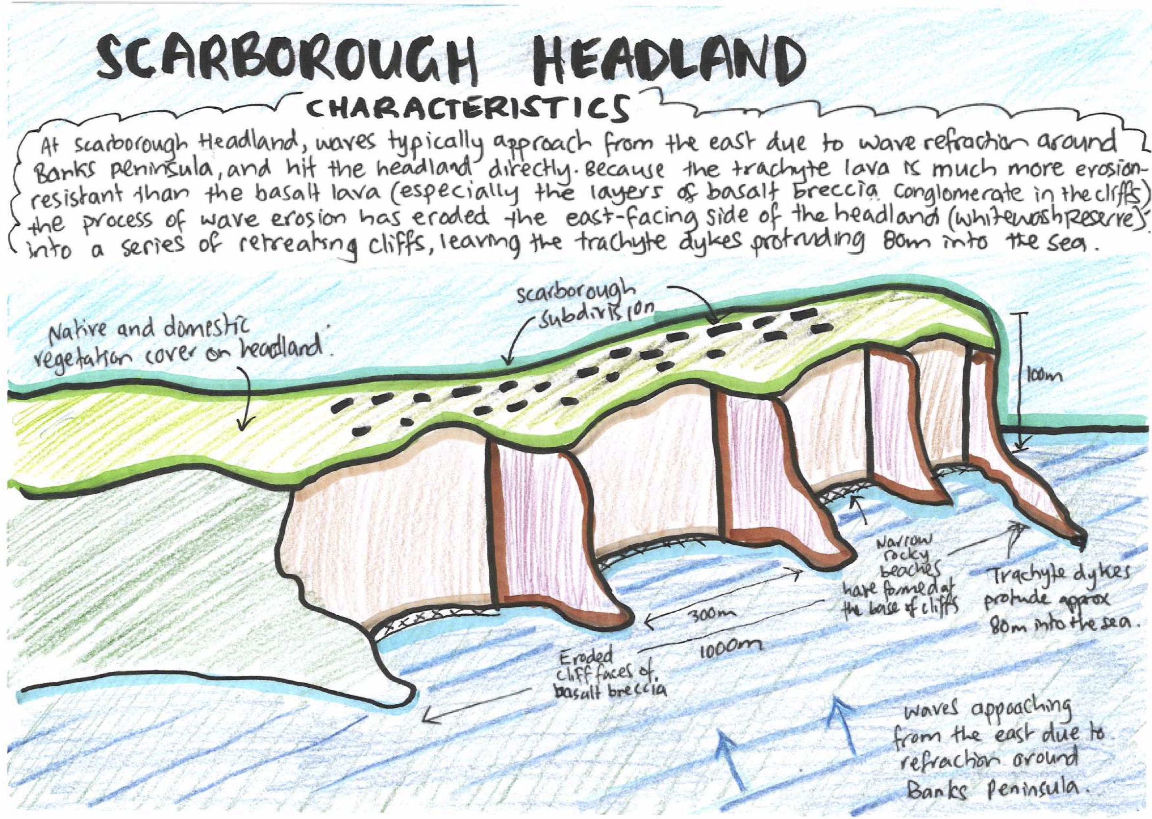
The headland rises around 110 metres and is made largely of fractured and jointed basalt lava. It also has significant intrusions of trachyte lava, which form horizontal sills in the cliffs as well as several prominent vertical dykes. The headland is a remnant of the Lyttelton caldera that formed from a sequence of volcanic eruptions 10.5 million years ago.
Aeolian transport and deposition have resulted in the headland being overlaid with a 40 cm layer of wind-blown loess soil, and it is fully developed with housing on top, along with fully vegetated properties.
Why the dykes stick out
At Scarborough Headland, waves typically approach from the east, due to wave refraction around Banks Peninsula, and hit the headland directly. Because the trachyte lava is much more erosion-resistant than the basalt lava (especially the layers of basalt breccia conglomerate in the cliffs), the process of wave action has eroded the east-facing side of the headland (Whitewash Reserve) into a series of retreating cliffs, while leaving the trachyte dykes protruding into the sea.
How the cliffs formed
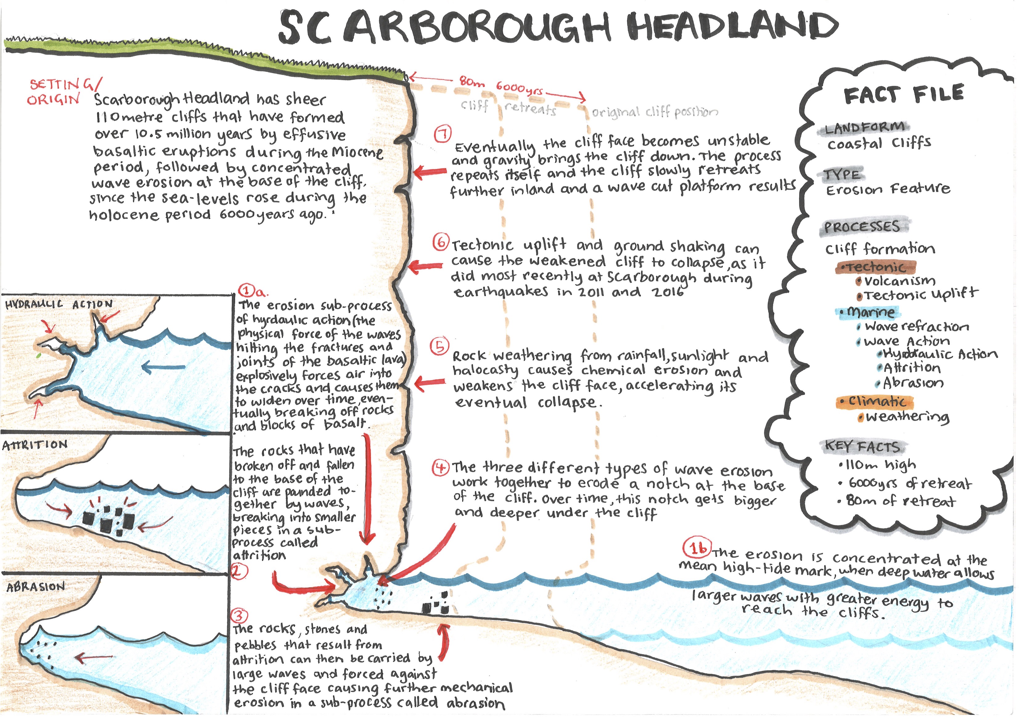
At Scarborough Headland, sheer 110 metre high cliffs have been formed over 10.5 million years by effusive basaltic eruptions during the Miocene period, followed by concentrated wave erosion at the foot of the cliff since sea levels rose during the Holocene period 6,000 years ago. The erosion is concentrated at the mean high-tide mark, when deep water allows larger waves with greater energy to reach the cliffs.
Wave erosion sub-processes
The erosion sub-process of hydraulic action (the physical force of the waves hitting the fractures and joints of the basaltic lava) explosively forces air into the cracks and causes them to widen over time, eventually breaking off rocks and blocks of basalt.
The rocks that have broken off and fallen at the base of the cliff are then pounded against each other by waves, breaking into smaller pieces, in an erosion sub-process called attrition.
The rocks, stones and pebbles that result from attrition can then be carried by large waves and forced against the cliff face, causing further mechanical erosion in a sub-process called abrasion.
Undercutting and collapse
These three wave erosion sub-processes (hydraulic action, attrition and abrasion) work together to erode a notch at the base of the cliff. Over time, this notch gets bigger and deeper under the cliff. Eventually the cliff face becomes unstable and gravity brings the cliff down.
In the SECCE, rock weathering from rainfall and haloclasty accelerates this process, when the breaking waves at the base of the headland send salt spray upwards, coating the cliff face. This salt water evaporates, leaving salt that causes chemical weakening of the rocks.
Additionally, tectonic uplift and associated ground shaking can cause the weakened cliff to collapse, as it did most recently at Scarborough during the earthquakes in 2011 and 2016.
Cliff retreat
This combination of wave erosion, weathering, haloclasty and cliff collapse repeats itself, and the cliff slowly retreats further inland, leaving a wave-cut platform. At Scarborough Headland, the cliffs have retreated around 80 metres inland compared with the erosion-resistant dykes, which remain protruding into the sea. A wave-cut platform extends around 25 metres at low tide.
The diagrams
Fact file
- Landform
- Coastal cliffs
- Type
- Erosion feature
- Processes
- Volcanism · Wave refraction · Wave erosion (hydraulic action, attrition, abrasion) · Weathering · Haloclasty · Tectonic uplift
- Key facts
- Cliffs about 110 m high · Basalt with trachyte sills and dykes · Remnant of the Lyttelton caldera (10.5 million years) · 40 cm of loess on top · Cliffs retreated about 80 m · Wave-cut platform about 25 m at low tide
Using it in the exam
Question B (how processes interacted to form ONE landform): this is our most detailed landform, so if the question asks about the interacting processes that build ONE landform, use this one. Write a sequence of paragraphs showing the steps: creating the cliffs in the first place, undercutting the cliff with erosion, then the cliff collapsing, and the process repeating so the cliff keeps retreating and exposes the trachyte dykes. You could start like this:
“One of the most significant landforms in the SECCE are the coastal cliffs at Scarborough Headland. These coastal cliffs have been formed by the interaction of volcanism and wave erosion, along with several other processes (wave refraction, weathering, haloclasty, tectonic uplift) and sub-processes (hydraulic action, attrition and abrasion).”
Question C (spatial variation): at Scarborough Headland the waves hit it directly, leading to cliff formation and sheer coastal cliffs. Whereas at Black Rock Point, refraction means the waves attack from all sides of the peninsula, leading to headland retreat (caves, arches, stacks, stumps).
Practise it: how hydraulic action, abrasion and attrition are related (paragraph) and formation of a coastal landscape (essay).