Spatial Variation
North to south across the SECCE · Question C
The pattern
The Southeast Christchurch Coastal Environment (SECCE) shows a clear spatial variation from north to south.
The northern coast, from New Brighton to the Southshore Spit, is a zone of accretion, where more sand is deposited than is removed, so the shoreline builds seaward at an average of 0.51 metres a year. The southern coast, from Scarborough Headland to Taylors Mistake and Black Rock Point, is a zone of erosion, where the sea removes more material than it deposits, and the coast is cut back at around 1.3 centimetres a year at Scarborough.
The pattern exists because the two ends of the SECCE are built from different material, receive different amounts of sediment and are hit by very different amounts of wave energy.
Why the pattern exists
1. What lies beneath each area
The southern coast is the eroded remnant of the Lyttelton Volcano, built by basaltic eruptions around 10.5 million years ago in the Miocene and later intruded by resistant trachyte. This solid volcanic rock forms headlands that project into the sea.
The northern coast has no rock at the shore. It is made of sediment carried to the coast by the Waimakariri River, 12 kilometres to the north, which delivers about 745,000 cubic metres of sand each year. Longshore drift carries this sand southeast along the beach at up to 7 metres per minute, so the north has a constant supply of material to build with, while the south’s sediment is what it erodes from its own cliffs.
2. How wave energy is distributed
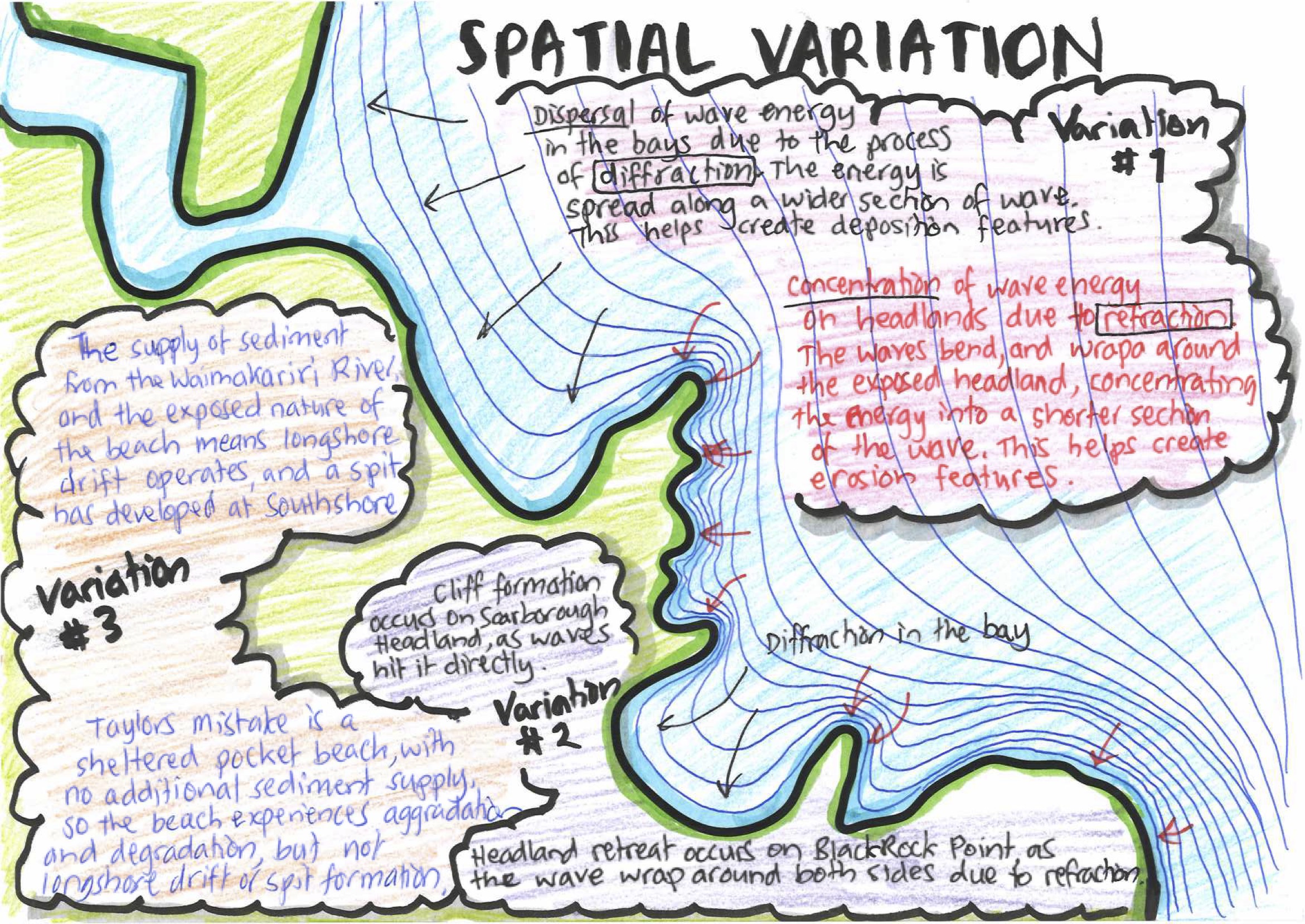
Waves approaching from the south and southeast are refracted around Banks Peninsula and reach the SECCE from the east. Along the irregular southern coast they are refracted again around each headland: the wave fronts bend onto the headland, concentrating their energy on a short section of coast, so Scarborough Headland and Black Rock Point take the full force of the sea.
In the bays between them the opposite happens. Diffraction spreads the wave energy out as the waves bend into the bay, so a bay such as Taylors Mistake is a low-energy zone.
The open northern beach has no headlands to concentrate energy, and the waves arrive as constructive waves, 0.5 to 2.0 metres high with a long period of 7 to 11 seconds. They break with a spilling action, and their backwash is weak because the water percolates into the sand and the beach slope is gentle, so more sand is carried up the beach than is taken back.
Key figures
- North
- Accretion · shoreline builds seaward about 0.51 m a year
- South
- Erosion · coast cut back about 1.3 cm a year at Scarborough
- Sediment
- Waimakariri River, 12 km north · about 745,000 m³ of sand a year · longshore drift up to 7 m a minute
- Rock
- Lyttelton Volcano basalt (10.5 million years) with trachyte intrusions
- Waves
- From the east · 0.5 to 2.0 m high · period 7 to 11 seconds
The five spatial variations
- Refraction and diffraction (the main variation). Waves approach the SECCE from the east and slow down as they reach shallower water. Off a headland the water shallows first, so that part of the wave front slows while the sections either side keep moving, and the wave bends (refracts) onto the headland. The wave fronts crowd together and concentrate their energy on a short stretch of coast, so Scarborough Headland and Black Rock Point are attacked by hydraulic action and abrasion and are dominated by erosion features: cliffs, caves, arches, stacks and stumps. In the bays the opposite happens. As waves pass the tip of a headland into a bay they diffract, spreading the same energy along a much wider shoreline. Wave energy drops, the waves can no longer carry their load, and sediment is deposited, which is why sheltered bays such as Taylors Mistake hold beaches. The result is an alternating pattern of high-energy, eroding headlands and low-energy, depositing bays. This is the main reason the SECCE varies from place to place.
- The composition of the landscape. Closely linked to the first variation, the geology of the coastline controls where headlands and bays form. The southern coast forms part of Banks Peninsula, the eroded remnant of the Lyttelton Volcano. It is composed of resistant basalt lava flows, intruded in places by trachyte, which produce an irregular coastline of headlands and bays. Because these rocks are resistant to erosion, rates of cliff retreat are low, at about 1.3 centimetres a year at Scarborough. In contrast, the northern coast forms part of Pegasus Bay, on the margin of the Canterbury Plains. It is composed of unconsolidated sand and gravel transported from the Southern Alps by the Waimakariri River. Unconsolidated sediment cannot form headlands, so the shoreline is long, straight and regular, and is shaped mainly by deposition. This coast is also geologically young: around 6,500 years ago the sea extended about 10 kilometres inland of the present shoreline, and the coast has advanced seaward since then as river sediment has accumulated.
- Orientation of headlands. Scarborough Headland faces the incoming wave fronts directly, so wave energy is concentrated on its seaward face, producing steep, sheer coastal cliffs. The headland contains resistant trachyte, which allows the cliffs to stand as a near-vertical face. Black Rock Point projects into the sea as a narrow peninsula, so refraction brings wave fronts against it from several sides at once. It is composed of jointed basalt with no trachyte, and erosion is concentrated along these joints, producing the landforms of headland retreat: caves, arches, stacks and stumps.
- Two kinds of beach. New Brighton and Taylors Mistake are both beaches affected by constructive and destructive waves. However, the barrier beach at New Brighton has longshore drift and a sediment supply from the Waimakariri River, creating a spit at the end of the beach, while Taylors Mistake is a pocket beach with a closed sediment system.
- Sediment supply from rivers. The Waimakariri River drains a large catchment reaching back to the Main Divide of the Southern Alps, where young, steep mountains are being worn away quickly. It delivers a huge sediment load to the coast north of the SECCE, and longshore drift carries this sand south to New Brighton and the Southshore Spit, feeding accretion. The Avon (Ōtākaro) and Heathcote (Ōpāwaho) rivers have small, low-lying urban catchments. The Avon is spring-fed, rising in Avonhead, so it carries very little sediment, and what the Heathcote carries is mostly fine silt that settles in the estuary rather than sand that reaches the beaches. Beach sand therefore comes almost entirely from the north.
The diagram
Time-lapse video of the diagram
Using it in the exam
Question C (what spatial or temporal variations exist): draw a map of the whole SECCE with wave fronts showing where energy is concentrated and dispersed. Start your first wave front close to the coast. In the bays, space the wave fronts apart; at the headlands and peninsula, draw them very close together. Further out to sea they smooth out, until they are nearly straight and show the waves approaching from the east.
Add annotations (a short sentence or two each, somewhere between a label and a paragraph) to show the variations, and make sure there is a title, north point and scale.
Writing: introduce the SECCE and the processes, landforms and variations you’ll talk about, then write a solid paragraph on each of the five variations above. Name the geographic concepts explicitly: “This shows the geographic concept of …” (interaction, change, processes, systems). You could start like this:
“The Southeast Christchurch Coastal Environment (SECCE) is located around 6 km southeast of Christchurch. The SECCE coastline extends along a 7 km arc from New Brighton Beach in the north to Godley Head in the southeast. A combination of tectonic, marine, fluvial and tidal processes occur in the SECCE, but some of these processes operate differently in parts of the environment. The main spatial variations relate to wave action, where wave erosion dominates along some parts of the coast, while wave deposition alters other sections. There are also variations in how wave erosion operates on different types of headland, and in the sediment supply at different beaches in the SECCE.”
Real student answers (2024, NZQA): Excellence · Merit/Excellence · Achieved/Merit
Practise it: Build the Answer, the Essay Builder and the spatial variation essay.